HISTORY of the area now known as the
Ría Lagartos Biosphere RESERVE
Yucatán, México.
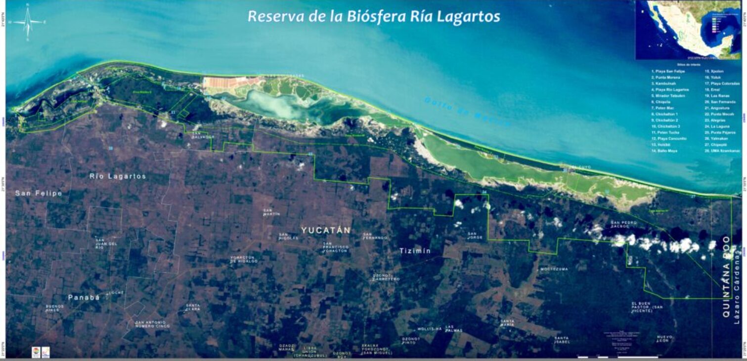
Ría Lagartos Biosphere Reserve Protected Natural Area where the greatest biological diversity is concentrated, as well as ecosystems with the best state of conservation in the Yucatan Peninsula. Ría Lagartos Biosphere Reserve is enlisted as Ramsar Wetland Site #331, described as a “wetland reserve of importance especially for the conservation of aquatic birds.” Read more about this distinction on our Ramsar Page.
During their tour of that area of the Mayab, the conquerors noticed the presence of large reptiles with enormous jaws and long tails that they identified as lizards. In reality they were crocodiles, but this species was not known in Europe; The closest thing was the lizards, just as feared as the first.
For that reason, the Spanish called the place Río Lagartos.
Five centuries after that event, today we know that it was not a river but a “ria”, that is, a flow of sea water that runs between the mainland and a narrow strip of beach and that it is a vast wetland of international importance: there is the main nesting area, in the country, of the pink flamingo (Phoenicopterus ruber ruber).

Protected from their natural predators and the presence of man, flamingos reproduce in large numbers to color the murky waters of the swamp with the pink of their plumage, which contrasts with the green foliage of the mangrove in the petenes, the blue of the sky and the amber tones of dawn or the orange of dusk.
However, that part of Yucatán is much more than a nesting area, since there some 340 species of birds, 50 of mammals and 95 of reptiles share the spectacle of life every day.
The natural wealth and non-renewable resources that this area has is such that on June 26, 1979 it was declared a Special Biosphere Reserve, which made it an area protected by the Federal Government.
The decree establishes the protection of 58,824 hectares of jungle, dunes, mangroves, beaches and with the largest Estuary (90km long) of the Yucatan Peninsula , which covers the communities of San Felipe, Río Lagartos, Las Coloradas and El Cuyo. The region, as a whole, today has a population of almost seven thousand inhabitants, the majority dedicated to fishing or working in the salt industry, the largest and most important of its kind in Yucatán.
The area was reclassified as the Ria Lagartos Special Biosphere Reserve.
MAYA RUINS IN THE BIOSPHERE
At least 18 archeological sites are identified within the Reserve area. Of these, Mexico’s Instituto Nacional de Antropología e Historia considers the site of Emal the most important. Other sites occur near El Cuyo. When the access road to El Cuyo was built, stones from the ruins were used. Along the estero’s margins, three concheros or conchales — zones where the ancients left significant accumulations of shells from their meals. In a location known as Alegría six sites are reported, but so far have not been studied, and no efforts are being made to conserve them.

During the 800s, the great classical Maya powers south of the Yucatan mysteriously suffered major political collapse. Cities were abandoned, great dynasties were ended, and Maya activity shifted northward. Closer to our area, the cities of Chichén Itzá and Uxmal grew and became more important. Chichén Itzá became what was probably the largest, most powerful and most cosmopolitan of all Maya cities. However, even Chichén Itzá eventually lost most of its power, by about 1250.

With Chichén Itzá gone, Mayapán 40 kms southeast of Mérida became a power, more or less uniting the northern Yucatan’s Maya under one government. However, in 1441, Mayapan itelf was sacked, burned, and abandoned. All the region’s larger cities went into decline, and Yucatan’s Maya populations devolved into warring city states.

Thus, when the first Europeans arrived in the Yucatan, Maya civilization already had reached its peak and collapsed. There were plenty of Maya people still occupying the land, but Maya power and glory were long past.

FIRST PUBLISHED MENTION OF RÍA LAGARTOS
The first published mention of the estuary now known as Ría Lagartos was in a map accompanying the 1511 publication De orbe novo by Peter Martyr d’Anghiera. Click on the thumbnail at the right to see the map in larger scale.
In 1517 the Spanish foot soldier Bernal Díaz del Castillo was part of an expedition of Francisco Hernández de Córdoba along the Yucatán Peninsula’s northern coast. In 1632, after Bernal’s death, his Historia verdadera de la conquista de la Nueva España was published, in which, in the fifth chapter, he mentioned visiting the estuary. He wrote:
“Y había en aquel estero muchos y grandes lagartos, y desde entonces se puso por nombre el Estero de los Lagartos, y así está en las cartas de marear”
And in that estuary there were so many big lizards that it has always been called El Estero de los Lagartos, by which name it is marked on the charts.


THE ANCIENT MAYA
The ancient Maya civilization reached its peak of power and glory during its “Classic Period” between AD 250-900. The great city-states of that time included Tikal in Guatemala and Calakmul is southern Campeche state, Copán in Honduras, and Palenque and Yaxchilan in Chiapas. Here along the Yucatan Peninsula’s northern coast, we were far from most of the action, though long distance Maya traders visited in their merchandise-filled canoes, and certain northern Maya cities did exist at this time, such as Dzibilchaltun ten miles north of Mérida

SPANISH CONQUERERS ARRIVE
When Spanish conquistadors arrived in the Yucatan Peninsula the Maya world was divided into various chiefdoms. The Ría Lagartos area belonged to the chiefdom of Chikinchel. The following map shows chiefdoms of the Yucatan Peninsula in 1500, according to Ralph Roys of Tulane and the University of Washington, and the Carnegie Institute. The map is based on a copyright-free Wikipedia image.

The Spanish conquerers described the citizens of Chikinchel as refined in their manners and speaking. The chiefdom’s principle city was Chauaca, beside a freshwater lake, near where the city of Valladolid originally was built, about 14kms south of present-day El Cuyo, and where little is to be seen today but Maya ruins, the tallest of which rises about 12 meters. On the above map, Chauaca was about where the H is in the red-printed Chikinchel. Later the Maya inhabitants were concentrated by the Spanish in what presently is Tizimín. In 1579, only 20 Maya families lived where once Chauaca had flourished.
During the 1500s, Ría Lagartos Estuary was famed among the Maya for producing such fish as Snook (Centropomus undecimalis), & Spotted Seatrout (Cynoscion nebulosus), and Red Grouper (Epinephelus moriomero), which were transported overland to the new cities of Valladolid and Mérida. At this time at El Cuyo a Maya port was in operation. Today a pyramidal structure between six and seven meters high exists (±20ft) atop a platform of about two meters height (7ft). Today a modern lighthouse stands atop the pyramid.
Taking into account the above map of Chiefdoms of the Yucatan Peninsula in 1500, it becomes easier to accept an assertion of Restall and Hostettler in 2001, that during colonial times the indigenous inhabitants of the Yucatan
peninsula did not see themselves as members of a common ethnic group.1& The concept of their constitution a “Maya people” was imposed from the outside. Some believe that “the Maya” began to think of themselves as one people only during the Caste War (1847 to 1901).
COLONIAL TIMES
Once Spanish soldiers occupied a region, the encomienda system was established, which was basically slavery, with the Maya forced to pay tribute to and work for Spanish soldiers, Spanish colonists and others. In an effort to convert the indigenous people to the Catholic faith, Franciscan priests built more than 30 convents in Yucatán, including one in Tizimín just south of us, in 1563. In 1562, Franciscan monk Fray Diego De Landa ordered all handmade Mayan books and statues to be destroyed, of which very few survived. Spanish oppression and diseases reduced the Yucatan’s native population from about 5 million in 1500 to 3.5 million a century later.
You can freely download, in PDF format, a detailed account of the colonial community of San Fernando Aké in Spanish. Use a search engine to find Jorge Victoria Ojeda’s El Sitio de San Fernando Ake Yucatán. Una Perspectiva Prehispánica e Histórica.
In the late 1700s, after Spain failed to take Haiti from France, King Carlos IV of Spain sent about a hundred former black slaves who had fought the French and now could not remain in Haiti to the Yucatan. Specifically, they were sent to a very isolated spot near Tizimín area, where they founded the community of San Fernando Aké in a spot where Maya ruins already existed. English artist Frederick Catherwood visited the community in 1843, finding the blacks in a disorganized but free state. In 1855, many people of the entire region, including most if not all of San Fernando Aké’s population, emigrated to Belize, largely to escape the violence of the Caste War, and perhaps to go to where blacks were present in much larger numbers.
Some say that the site of San Fernando Aké is connected by an ancient Maya sabé, or road, with the ancient coastal site of Emal, to be spoken of later.
In the Yucatan Peninsula, over time the encomienda system was replaced by the hacienda system, in which the Maya found themselves working for Spanish landowners, and later the hacienda system evolved into a kind of market economy. These transition were slow and uneven. In some areas, what could be called the encomienda system — though long outlawed — endured into the early 1900s. Our area was out of the mainstream of things and the Yucatan was not the most important part of the Spanish empire. Spanish rule here was weak, and the Maya impoverished. The Catholic Church was more successful in exercising power and bringing about lasting changes.

From William Dampier’s 1705 book: Mr. Dampier’s Voyages to the Bay of Campeachy, Vol II part II. The passage describes a visit in 1675 to Cabo Catoche at the Yucatan Peninsula’s northeastern-most point:
It is all over-grown with Trees of divers sorts, especially Logwood; and therefore was formerly much frequented by the Jamaica Men, who came thither in Sloops to load with it, till all the Logwood trees near the Sea were cut down; but now ’tis wholly abandoned, because the Carriage of it to the shore repuires more labour, than the cutting, logging and chipping. Besides they find better Wood now in the Bays of Campeachy and Honduras, and have but a little way to carry it; not about 300 Paces, when I was there: whereas at Cape Catoch they were forc’d to carry it 1500 Paces before they left that Place.
CUTTING LOGWOOD
A document dated 1878 (AGEY, Fondo Poder Ejeutivo, Sección Gobernación, Serie Correspondencia Oficial, Mérida, Caja 203) refers to the commercial cutting of Logwood in coastal Yucatan, including in our area, in San Felipe, Río Lagartos, El Cuyo and San Fernando.
Mexico’s CONANP agency (Comisión Nacional de Areas Naturales Protegidas) provides a detailed look at many aspects of Ría Lagartos Biosphere Reserve, including lists of plants and animals, in a freely downloadable PDF document in Spanish entitled Programa de Conservación y Manejo Reserva de La Biosfera Ría Lagartos
THANK YOU VERY MUCH TO NIÑOS & CRIAS, A.C. AND CONANP THE DIRECTION OF THE RIA LAGARTOS BIOSPHERE RESERVE FOR SUCH MAGNIFICENT CONSERVATION WORK OF THIS PRIVILEGED ECOLOGICAL ZONE. Mexico’s CONANP agency (Comisión Nacional de Areas Naturales Protegidas) provides a detailed look at many aspects of Ría Lagartos Biosphere Reserve, including lists of plants and animals, in a freely downloadable PDF document in Spanish entitled Programa de Conservación y Manejo Reserva de La Biosfera Ría Lagartos
http://www.conanp.gob.mx/anp/consulta/PCM_RiaLagartos.pdf
http://www.biodiversidad.gob.mx
PLANTS:more than 520 species
- Endemic species:
- Cactus: Pilosocereus gaumeri
- Cactus: Mammillaria gaumeri
- Cactus: Nopalea gaumeri
- Grass: Eragrostis yucatana
- Palm: Coccothrinax readii
- Palm: Pseudophoenix sargentii
- Tree: Acacia gaumeri
- Shrub: Enriquebeltrania crenatifolia
- Threatened species:
- Orchid: Rhyncholaelia digbyana
- Palm: Coccothrinax readii
- Palm: Thrinax radiata
- Palm: Pseudophoenix sargentii
Check out our WOODY PLANTS OF THE RESERVE
ANIMALS:
Birds: 395 bird species
• 117 resident species
• 142 migratory
• 14 resident-migratory
• The wetlands sustain the largest number of nesting pairs (89 percent) of the Greater Flamingo in mainland North America
• Endemic or near-endemic to the Yucatan:
◦ Yucatan Wren (Campylorhynchus yucatanicus)
◦ Mexican Sheartail hummingbird (Doricha eliza)
◦ Yucatan Bobwhite (Colinus nigrogularis)
◦ Zenaida Dove (Zenaida aurita)
• Threatened species:
◦ Least Tern (Sterna antillarum)
◦ Yellow-lored Parrot (Amazona xantholora)
◦ Peregrine Falcon (Falco peregrinus)
◦ Piping Plover (Charadrius melodus)
• Seldom seen elsewhere in Mexico:
◦ Kelp Gull (Larus dominicanus)
◦ Lesser Black-backed Gull (Larus fuscus)
Reptiles: 95 species
• 4 marine turtle species, two endangered by extinction
Fish: 71 species
• Of special commerical value:
◦ Dark Sea Catfish (Arius melanopus)
◦ Western Atlantic Seabream (Archosargus rhomboidalis)
◦ Mayan Cichlid (Cichlasoma urophtalmus)
◦ Pigfish (Orthopristis chrysoptera)
◦ Mullet (Mugil sp.)
◦ Robalo (Centropomus ronchus)
Mammals: 55 species
• Notable species:
◦ Jaguar, Panthera onca
◦ Ocelote, Leopardus pardalis
◦ Margay, Felis wiedii
◦ Jaguarundi, Herpailurus yagouaroundi
RÍO LAGARTOS’S HOTEL NEFERTITI
The large, modern hotel on Río Lagartos’s wester shore (the side facing the canal leading to the Gulf) as late as 2016 was a big, white, abandoned, forlorn-looking building. Today it’s quite fancy looking, and its history was an important part of the history of Río Lagartos itself.
Construction on it began in 1965, with the filling-in of the estuary at that spot. The force behind the building was Sr. Dante López Díaz, a native of the area who had gone to Mexico City and succeeded in making some money. The hotel began operation in 1970, christened as the Hotel Nefertiti, named after the owner’s wife. A few years later the hotel was sold to Sr. Bernardo Massa of the area, who in 1975 added the town’s first restaurant, the Restaurant Flamingos, constructed as a huge, Maya-type, thatched-roof hut.
Of course with a name like Nefertiti, the hotel and restaurant had a theme, so eventually when you walked into it you’d encounter decor and works of art suggestive of ancient Egyptian splendor. But what folks seemed to like was the disco music and the inside pool filled with crocodiles. Mainly the guests were Italians, French and North Americans.
In 1988 Hurricane Gilbert destroyed the restaurant and seriously damaged the hotel. That was the end of Hotel Nefertiti, until its recent reconstruction.
Old timers today say that at first Río Lagartos was little more than Hotel Nefertiti, with a few thatch-roofed, pole-walled houses clustered around it. There were several wonderful, fresh-water springs, which now have been covered and paved over. Much more landfill has been dumped around the original peninsula, enlarging it. We’re told that in the early days everyone’s toilet was built over the water so that fish ate what dropped through the holes. In the cemetery, people were buried in wooden caskets, which leaked, so that whenever the tide went out, you could see something like oil floating atop the water. “But people didn’t get sick,” we’re told.
Reopen in 2020 as Rio Lagartos Hotel.
THE ESTUARY OF RÍA LAGARTOS BIOSPHERE RESERVE
SALINITY & FISH: The Peralta-Meixueiro study referenced below2 found that in the Ría Lagartos Estuary species diversity of fish was lower than that in other similarly located estuaries. The suggested reason for this is that, more than in other similar estuaries, the waters of Ría Lagartos Estuary are especialy high in salt content throughout the year and throughout the lagoon system. Salinity inside the estuary rapidly increases toward the interior (from west to east). The Valdes & Real study referenced below4 found that during the dry season the estuary’s average salinity was over 69 PSU (seawater’s is around 35.5 PSU), and in some parts of the estuary’s inner zone it was 147 PSU — over 3.5 times saltier than sea water.
Especially at the estuary’s mouth at San Felipe and across from Río Lagartos where the canal cuts through the thin finger of land separating the estuary from the Gulf, most organisms found in the estuary may also occur in the Gulf. Therefore, many organisms found in the estuary are listed on our Marine Page and many others are not listed at all. Also, populations of individual species vary strongly from year to year. Finally, we can see that the estuary’s biota is changing overall, so these lists may be a little out of date.
The estuary — known as a ría in Spanish.
Characteristic aquatic PLANTS & plant-like things:
“SEAGRASSES”
animals that might look like algae
ALGAE:1
- GREEN
- BROWN/ GOLDEN
- ± WHITE
Characteristic aquatic ANIMALS:
NOTE:
Most numerically abundant fish species, (2004-2008)2:
- Ocellated Killifish, Floridichthys polyommus
- Checkered Puffer, Sphoeroides testudineus
- Yucatan Pupfish, Cyprinodon artifrons
- Silver Jenny, Eucinostomus gula
- Silver mojarra, Eucinostomus argenteus
Fish providing most biomass (2004-2008)2:
- Checkered Puffer, Sphoeroides testudineus
- Ocellated Killifish, Floridichthys polyommus
Fish in least salty water (2004-2008)2:
- Mayan cichlid, Cichlasoma urophthalmus
- Yucatan Molly, Poecilia velifera
- Checkered Puffer, Sphoeroides testudineus
- Hardhead Sea Catfish, Ariopsis felis
- Redfin Needlefish, Strongylura notata
Fish in most salty water and water with least oxygen (2004-2008)2:
- Ocellated Killifish, Floridichthys polyommus
- Yucatan Pupfish, Cyprinodon artifrons
A 2010 description of Ría Lagartos’s waters by ecologists Herrera-Silveira & Morales-Ojeda:3 “Because this system is located within a watershed infuenced by agriculture and cattle farming, groundwater is contaminated, and early signs of eutrophication and pollution have been observed. The impact of SGD-derived pollutants may be magnifed by the long water residence time (about 450 days)”
At the end of May, 2015, on the afternoon of the first day after the first rain of the rainy season, in certain spots the estuary smelled strongly of cow manure, though the wind was not from the ranchlands to the south. Jim Conrad suspects that rainwater from the southern ranchlands arrived in the estuary via underground rivers, carrying the manure’s odor, and who knows what bacteria and chemicals?
Endemic fish species:
Specially protected fish:
- Yucatan Molly, Poecilia velifera
- Mayan Cichlid, Cichlasoma urophthalmus
Comercially most important fish species:
- Gray Snapper, Lutjanus griseus
- Sand Seatrout, Cynoscion arenarius
- Spotted Seatrout, Cynoscion nebulosus
Other Important AQUATIC ANIMALS
- Red Shrimp, Farfantepenaeus brasiliensis
- Blue Crab, Callinectes sapidus
- Durophagous Stone Crab, Menipe mercenaria
- Ornate Blue Crab, Callinectes ornatus
- CROCODILES
- Octopus, Octopus maya
References:
1 G Morales y I Ortegón, Distribución de la flora ficológica en la Costa de Yucatán in 3er Simposium sobre el Conocimiento de los Recursos Costeros del Sureste del México, Universidad Autónoma de Yucatán. Mayo 29, 2013-Mayo 30, 2013
2Peralta-Meixueiro, Miguel Angel et al, “Evaluación Espacio-temporal de los Ensamblajes de Peces en el Sistema Lagunar de Ría Lagaratos, México” in Proceedings of the 63rd Gulf and Caribbean Fisheries Institute, November 1-5, 2010, San Juan, Puerto Rico
3 Jorge A. Herrera-Silveira & Sara M. Morales-Ojeda, “Subtropical Karstic Coastal Lagoon Assessment, Southeast Mexico The Yucatan Peninsula Case” in Coastal Lagoons Critical Habitats of Environmental Change, Edited by Michael J . Kennish and Hans W . Paerl, CRC Press 2010
4 David Valdes & Elizabeth Real, “Nitrogen and phosphorus in water and sediments at Ria Lagaratos oastal lagoon, Yucatan, Gulf of Mexico,” Indian Journal of Marine Sciences Vol. 33(4), December 2004.
1 Restall, Matthew, and Ueli Hostettler. “Introduction: The Meaning and Mechanics of Maya Survivalism,” in Maya Survivalism. Acta Mesoamericana, Vol 12. Markt Schwaben, Germany: Verlag A. Saurwein.
2 Arenas Castillo, Sofía. “Conservación, procesos organizativos y participación en la Reserva de la Biósfera Ría Lagartos: El caso del turismo de observación de flamenco americana (Phoenicopterus ruber). El Colegio de la Frontera Sur. 2014.
Yucatan’s GEOLOGY
In general, the northern Yucatan Peninsula is characterized by these five notable features:
- It is flat and low
- Its bedrock is limestone
- The limestone is honeycombed with caves and sinkholes
- The limestone is very young, geologically speaking
- The Chicxulub Crater is centered on the coast of northwestern Yucatan
THE YUCATAN IS LOW AND FAIRLY FLAT
You can think of the Peninsula as a big slab of limestone gently tilted toward the sea all around. The farther south you go, the more likely you are to encounter low hills. By the same token, you must travel far offshore before you reach deep water.
If you travel Hwy 24 between Mérida and Campeche you’ll see some hills just to the east of the highway but the highest peak there is only 108 meters (354 feet). Farther inland, near Tekax, the highest hill, Cerro de Xal, is 250 meters (820 feet). The hills in this area are often called the Puuc Hills. Down south where the peninsula joins the mainland’s body there are other peaks just north of Hwy 186 running between Chetumal and Francisco Escárcega reaching 250 meters and bit more.
THE BEDROCK IS LIMESTONE
Limestone is soluble in water so the Yucatan’s limestone bedrock is honeycombed with caves and sinkholes — it’s classic karst topography. Yucatan’s sinkholes have a special name — cenotes (seh-NO-tehs). Cenotes are the result of caves collapsing, forming holes in the ground with water in the bottoms of the holes. Because the limestone has so many holes in it, there are no major rivers throughout the entire Yucatan Peninsula. Water runs underground.
THE LIMESTONE HAS MANY CAVES AND CENOTES
Cenotes are very important in Yucatan history and present life. Because of the lack of rivers, the ancient Maya took their water from cenotes. Cenotes were important in the Maya religion, being the home of gods. Sometimes humans were thrown into cenotes as sacrifices. Today underwater archeological teams are discovering many Maya artifacts in cenotes. Also, many divers enjoy exploring the Yucatan’s cenotes and underground rivers.
THE LIMESTONE IS YOUNG, GEOLOGICALLY SPEAKING
Much of the outcropping limestone in the northern Yucatan is part of the Carrillo Puerto Formation of Miocene-Pliocene age. The Miocene and Pliocene are often considered as having occurred from 23.8 to 1.8 million years ago. Along much of the Yucatan coastline you find Quaternary deposits 1.8 million years old and younger.
THE CHICXULUB IMPACT CHANGED LIFE ON EARTH
About 65 million years ago a large asteroid or comet hit the part of the Earth that today is just offshore, in the Gulf of Mexico, off the northwestern Yucatan Peninsula. The city of Mérida is regarded as lying within its impact zone, which today is referred to as the Chicxulub Crater. However, today there is no crater to be seen because it’s buried beneath 65 million years of sediment, much of which now has solidified to limestone. One reason the Chicxulub impact is of such interest is that it is thought to be responsible for the vast extinction of species that took place 65 million years ago. At that time dinosaurs were the Earth’s most advanced form of life. Probably the Chicxulub impact changed the Earth’s weather conditions so drastically that nearly all the dinosaurs died off. This enabled mammals to assume the dinosaur’s dominant position. Had it not been for the Chicxulub impact, we humans may not have evolved as we did, or evolved at all.
You can read a lot more about the Chicxulub Crater, see an animation of how the crater was formed, read about regional and global effects of the impact, and find more links on the matter on the Wikipedia Chicxulub Page.Wikipedia Chicxulub Page.